Ethiopian Demography and Health
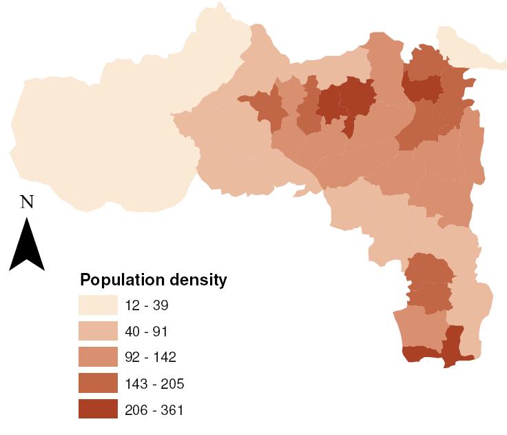
Population Density, Tigray 2008
Source: Based on data from the Central Statistical
Authority [9].
(persons per sq. km)
Tigray forms the northernmost reaches of Ethiopia, and is located between 36 degrees and 40 degrees east longitude. Its north-south extent spans 12 and a half degrees to 15 degrees north. It is bordered by Eritrea in the north, Sudan to the west, Amhara to the southwest and Afar in the east. It is a very historic region noted for its custodianship of “… one of the powerful civilizations of the ancient world, [which] was centered here from at least 400 BC to the 10th century AD. Spreading far beyond modern Tigray, it molded the earliest culture of Ethiopia and left many historical treasures: towering finely carved stele, the remains of extensive palaces, and the ancient places of worship are still vibrant with culture and pageantry.” [1]
Tigray had been in transition over the last quarter century having suffered the brunt of the 30-year war between Ethiopia and its former province of Eritrea which gained independence in the early 1990s. It suffered more from a renewed fighting in the year 2000 that led to further dislocation of the rural population in the border regions. This, on top of the seemingly unending impacts of drought, famine, and the serious (and insidious) impacts of environmental damage. The latter is a response to millennia of settlement in the region with few changes, if any, in farming practices which exposed the precious top layers of soils to erosion by the seasonal torrential rains of the summer months assisted by the rugged and steep landforms. Progress is slow, as a result as is the pace of life. “The highlands receive most of their rainfall during the summer months, much of which goes into tributaries of the Nile, 85% of whose water comes from Ethiopia. The soil has been depleted by many centuries of cultivation; water is scarce. Using methods that are thousands of years old, farmers plow their fields with oxen, sow seeds and harvest by hand. The harvest is threshed by the feet of animals. In the home, women use wood or the dried dung of farm animals for cooking. Women often work from 12 to 16 hours daily doing domestic duties as well as cultivating the fields.” [1]
Landforms and Climate
“Tigray is located at the northern limit of the central highlands of Ethiopia. The landform is complex composed of highlands (in the range of 2300.3200 meters above sea level, (masl), lowland plains (with an altitude range of <500.1500 masl)1, mountain peaks (as high as 3935 masl) and high to moderate relief hills (1600.2200 masl). Thus Tigray has diversified ago-ecological zones and niches each with distinct soil, geology, vegetation cover and other natural resources. The climate is generally sub-tropical with an extended dry period of nine to ten months and a maximum effective rainy season of 50 to 60 days. The rainfall pattern is predominantly uni-modal (June to early September). Exceptions to the rainfall pattern are areas in the southern zone and the highlands of the eastern zone, where there is a little shower during the months of March to mid May. Considering rainfall, atmospheric temperature and evapotranspiration, more than 90 percent of the region is categorized as semi-arid. The remaining areas in the region can be categorized as dry submoist (near the central south highlands and the Wolkite highlands) and arid (the lower areas of Erob and Hintalo Wajerat woredas). There are also some moist zone patches in the Kisad Gudo, Mugulat and the Tsegedie highlands.” [2]
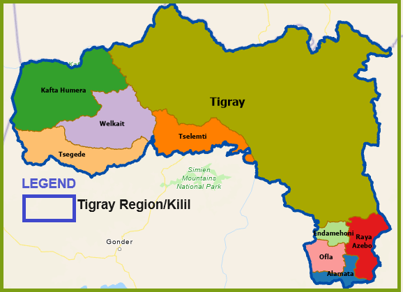
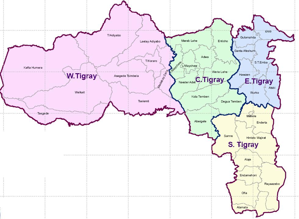
The region is divided into four zones – West Tigray, East Tigray, Central Tigray, and Southern Tigray – and 35 Weredas (see map below) but is subject to revisions pending a future referendum in West and South Tigray zones.
Source [3].
An online source on the local environment and economy presents a clear picture of the major difficulties the region is facing today as the government currently in power whose top leaders are from this region strive to bring about positive change that can transform the region’s economy, and improve the environment. The following excerpts are obtained from this online source [4]
Environmental issues:
• Cultivable land is scarce with growing population
•All land is owned by state but user rights given to farmers and pastorlists
•The majority of the population in Tigray relies largely on peasant agriculture, but becoming (slowly)
more market oriented.
•The pressing environmental issues include soil erosion as well as reduced fertility and productivity,
gully formation, deforestation, pressure to cultivate slopping land, and use of dung for fuel rather than
as organic fertilizer
•Unable to afford inputs (because of high risk of crop failure)
•Vicious circle of over-use of land in order to meet basic food security causing decreased fertility
Economic issues:
•Difficulty of transportation due to the rugged terrain, a vicious cycle of poverty caused by over-use of land in order to achieve basic food security in ways that are highly detrimental to the health of the environment, inability to afford soil inputs, high risks of crop failure, rapid population growth, land tenure (last redistribution of land took place in 1991), land fragmentation, and landlessness, limited off-farm incomes, top-down technical approaches in proposed government solutions
Ongoing efforts to address environmental damage
•Soil/water conservation (SWC) measures supported by NGOs as well as the regional government technical officers, promotion of “area closures” to allow environmental regeneration, communal (tabia) resource management including state managed forest enclosures.
•Agriculture-Led Industrial Development (ALID) strategy adopted by the current government in power [5] to create strong linkages between the agricultural sector and the nascent industrial sector of the regional economy, thereby, alleviating chronic poverty, ensuring food security, and reducing the level of unemployment.
•Improved regional transportation access “… has contributed to agricultural development and improved resource management and human welfare” as has the overall improvement in education [6]
•Measures have been taken to “liberalize the input and output markets and increase institutional support for agricultural research and extension services” as well as “land registration aimed at improving farmer’s land tenure security” [7]
Recent droughts, their impacts, and government response
Draught and famine have been routine occurrences in the region since the 1970’s. One of the latest reports on the subject indicates that “… there are 1,831,600 people in need of relief food assistance in Tigray region (excluding West Tigray Zone) due to complete failure of belg and poor meher production [and] delayed on set of meher rains (by five months compared with the normal time)….”. The affected areas included “….Atsibi-Womberta, Wukro, Erob, Gulo Mekeda and Afherom Woredas in the Eastern Tigray Zone and Raya Azebo, Hintalo-wajirat, Alamata and Endamehoni in the South Tigray Zone. [8]. A mix of proposed solutions to confront the challenges includes resettlement. The idea of resettlement has not been new to Tigreans but the destinations, scale - the number of people involved - as well as the objectives have changed over time.
“The major objectives of current resettlement initiatives are mainly to reduce environmental degradation in areas of origin by transferring drought-affected people to more fertile and less populated areas for increased food production and subsistence farming. People affected by the Ethio-Eritrea border conflict that are said to have shown interest for resettlement may also be included for resettlement. One of the potential areas selected for resettlement is the Humera district of West Tigray Zone…. Most of the people will be moved from Central Tigray Zone and will settle along the Tekeze River and the Shiraro-Humera road …..” [8]
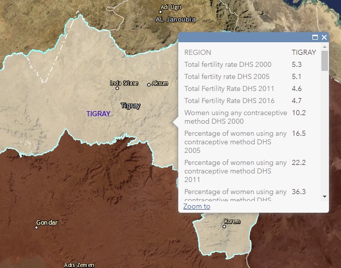
Population Distribution and Density
Tigray has an estimated population of 4,565,000 (July 2008) and an average density of 91.2 persons per square kilometers [9]. Wereda densities vary from a low of 12.3 persons per square miles in Kafta Humera to just over 250 persons per square kilometers in Adwa, Laelay Maichew, and Alamata (see map below).
TIGRAY
Refernces:
1.http://www.absoluteastronomy.com/topics/Tigray-Tigrinya_people
2.Belete Taffere (2002) Efforts For Sustainable Land Management in tigray: The Role of Extension, in Berhanu Gebremedhin, John Pender, Simeon Ehui, and Mitiku Haile (eds.) Policies for Sustainable Land Management in the Highlands of Tigray. EPTD Workshop Summary Paper no.14. Summary of Papers and Procedings of a Workshop. Axum Hotel, Mekelle, Ethiopia, March 28-29, 2002.
3. http://www.ocha-eth.org/Maps/downloadables/OROMIYA.pdf
4.http://www.ifpri.org/themes/ECAPAPA/ecapapaabout.asp
5.Haile Yohannes (2002) Overview of the Tigray National Regional State: Achievements of the First Five-Year Development of the First Five-Year Development Plan and Future Prospects, in Berhanu Gebremedhin, John Pender, Simeon Ehui and Mitiku Haile (eds.) Policies for Sustainable Land Management in the Highlands of Tigray. EPTD Workshop Summary Paper no.14. Summary of Papers and Procedings of a Workshop. Axum Hotel, Mekelle, Ethiopia, March 28-29, 2002.
6.John Penderet. et. al (2002) Agriculture and Land Management in the Highlands of Tigray: Causes and Implications, in Berhanu Gebremedhin, John Pender, Simeon Ehui and Mitiku Haile (eds.) Policies for Sustainable Land Management in the Highlands of Tigray. EPTD Workshop Summary Paper no.14. Summary of Papers and Procedings of a Workshop. Axum Hotel, Mekelle, Ethiopia, March 28-29, 2002.
7.Berhanu Gebremedihin, John Pender, and Simeon Ehui (2002) Land use, Land Tenure and Sustainable Land Management in Tigray, in Berhanu Gebremedhin, John Pender, Simeon Ehui and Mitiku Haile (eds.) Policies for Sustainable Land Management in the Highlands of Tigray. EPTD Workshop Summary Paper no.14. Summary of Papers and Procedings of a Workshop. Axum Hotel, Mekelle, Ethiopia, March 28-29, 2002.
8.Ahmed Ali Egeh and Dechassa Lemessa (2003). Updates on Humanitarian Situations of War and Drought Affected Population in Tigray. United Nations Emergency Unit for Ethiopia (UN-EUE)
9.http://www.csa.gov.et/text_files/national_statistics.htm
If you would like to help update this page, please send comments and/or data (as an e-mail attachment) to Dr. Aynalem Adugna
at aynalemadugna@aol.com. Don't forget to indicate sources.
| ||||||
THE RECENT ARMED CONFLICT AND POSSIBLE DEMOGRAPHIC CONSEQUENCES OF MASSIVE WAR CASUALITIES
The below statements are fairly incontrovertible, and are best read in chronological order
** The Tigrayan Peoples Liberation Front (TPLF) was formed nearly half a century ago. It soon took up arms against the government of Ethiopia vowing to win more rights and freedoms for the people of Tigray; rights that included seceding from Ethiopia all together.
** TPLF would eventually topple the national government (Derg) and seize power having formed a coalition known as the Ethiopian People's Revolutionary Democratic Front (EPRDF) which helped create a new constitution that included Article 39 - a guaranteed right of secession for any of the new ethnic (zer) based regions (kililoch)
** EPRDF's reign had lasted 27 years with TPLF's leader Meles Zenawi at the helm (for most of its existence) when it was finally toppled by widespread revolt. Prime Minister Meles Zenawi had passed away a few years prior.
** In an act that was portrayed as unwillingness to accede to the will of the people and share power equitably, TPLF left the comfort of Addis life with Mekele as its interim destination and with an urgent goal of masterminding a possible triumphant return to the seat of national government in Arat Kilo to restore itself to the highest levels of national power
** In an another action that gripped the attention of the international community and became the headline news around the world (until it was supplanted by the Russia-Ukraine war), TPLF fires the first shots of a battle that it thought would return it to power in the capital. Here, we are referring to the nightly assault on Ethiopian armed forces (Semien Ezz) while soldiers that were defending Tigray's borders were sound asleep. This took place on November 4, 2020. TPLF did not characterize it as an attempt to return to power, calling it instead an act of self-defense against a joint plot by the leaders of Ethiopian defense forces - Prime Minister Abiy Ahmed - and of Eritrean forces - President Esayas Afeworki - to launch a well-planned deadly first strike against it.
** In a counterattack, Ethiopian defense forces regrouped and seized the regional capital Mekele as well as Wolkyte and Humera which were part of Gonder Kifle Hager but were made part of Tigray in the early 1990s (see the below map for the location of Wolkyte and Humera). TPLF civilian and military leadership was forced to seek refuge in Kola Tembien hideouts, and many were killed. End of Round I
** In coordinated human-wave-like offensives that deployed both civilians and semi-trained fighters, TPLF lunched attacks that forced the Ethiopian military, to leave Tigray. However, Ethiopian defense forces continued to hold Wolkyte and Humera in western Tigray. TPLF and its diaspora supporters accused the Ethiopian and Eritrean military of genocide against the people of Tigray prompting US/EU to levy sanctions against the two counties including termination of Ethiopia's AGOA privileges by the US. The United Nations which met to discuss the accusations about a dozen times had assigned its own investigators.
** In rushed hot pursuits, TPLF takes all towns along the Mekele-to-Addis Ababa highway corridor including, Kobo, Woldiya, Dessie, Kombolcha, and arrives in Debre Sina just 190 Kilometers from Addis Ababa but was chased back to the vicinity of the borders of Tigray when the commander in chief of Ethiopian armed forces, Prime Minister Abiy Ahmed joined the fighting at the front lines. End of round II
** In August 2022 TPLF launches its third round of military campaigns citing acts of provocation from the Ethiopian military and retakes the town of Kobo but fails to take Woldia again in a clear sign that it had lost the capacity to be knocking on the doors of the capital Addis Ababa as it did in the second round. In a highly coordinated counterattack, the Ethiopian military retakes all lands in Afar and Amhara regions (including Raya which was part of Wollo Kifle Hager until the early 1990s - see the below map for the location of Raya) as well as major cities and towns in Tigray Region itself most importantly, Shire, Adowa, and Axum, and threatened Mekele. TPLF signs a peace deal in Pretoria South Africa to stop the fighting. This took place on November 2, 2022, just two days shy of the second anniversary of the attack on Semien Ezz and the start of the war. End of Round III
The below map shows the (unofficial) extent of Tigray Region (Kilil) at the conclusion of the third round of fighting and the signing of the peace deal. We called it unofficial as the status of Wolkyte and Raya sub-regions, namely Kafta Humera, Welkait Tsegede, Tselemt, Endamahoni, Raya Azebo, Ofla, Alamata Weredas, is yet to be determined in a constitutional process of public referendum. Below the current de facto map of Tigray are shown two age pyramids: (1) the likely age pyramid of Tigray Kilil on the eve of the war (November 3, 2020) and (2) the likely age pyramid of the population residing in the old extent of Tigray as of the signing of the peace deal on November 2, 2022 (Note: The two age pyramids should not be considered accurate, or quoted, or reproduced, as they are not based on real data). The second pyramid subtracts from the first pyramid the population that is residing in Wolkyte and Raya as well as causalities of war in front-line deaths and excess mortality resulting from the indirect effects of war including malnutrition and lack of health care. The second age pyramid also excludes Tigrayan refugees that fled into the Sudan, those who migrated to other parts of Ethiopia, and those who went to other foreign destinations seeking safety.
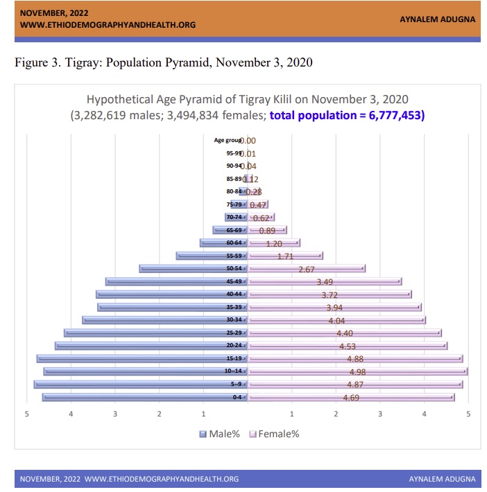
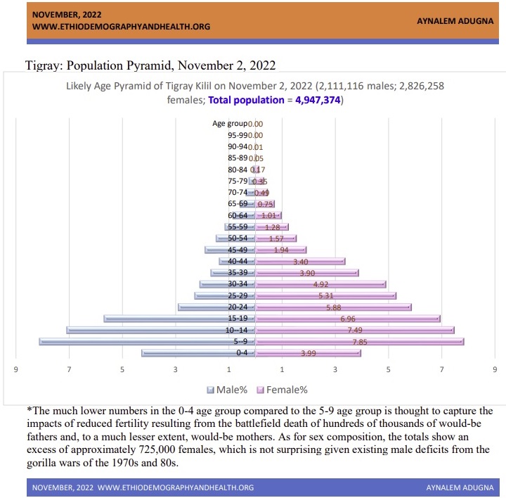
Summary: More on the Demographic Consequences of the War for the Population of Tigray
Consequences for Overall Population Size and Age Structure in Tigray
The difference between the above two population pyramids representing Tigray Region's age structure and population sizes at the start of the war in November 2020 and at the signing of the peace deal in November 2022, is profoundly powerful visual evidence of what was termed "demographic consequences of war" in the above subheading. The consequence is summed up in the changes in total population sizes which were estimated at just under 6.8 million in November 2020 and at just over 4.9 million in November 2022. The shrinkage in population size by nearly two million has been attributed in the above paragraphs to (a) reductions in the geographic extent of Tigray Kilil, at least temporarily, due to the war (b) front line deaths of Tigrayan youth numbering in hundreds of thousands as recently intimated by the African Union's (AU) peace negotiator and previously admitted by TPLF officials, (c) refugee flows to the Sudan (d) migration to other countries, and (e) relocation to other parts of the country.
Consequences for Balance of the Sexes in Tigray
The difference in the age structure represented by the two population pyramids is also dramatic for what it means for the future of Tigray especially as it is irreversible in the short term and takes more than a generation (the mean length of a generation in Ethiopia is about a quarter century) to fully "heal" or come back to normal. Equally concerning and profoundly consequential is the sex imbalance which had built up in Tigray through the war years of the 1970s and 1980s and was redressed during what could be described as the peace-dividend years of 1990s and the two decades of the 21st century. Unfortunately for the demographic future of Tigray, three rounds of fighting in the third decade of the 21st century have once again created substantial sex imbalances with male deficits increasing from around 200,000 at the start of the war to over 700,000 at the end of the war. Not all of the male-deficit is to be accounted for by excess male mortality. Greater out-migration of males than females also played a part.
Consequences for Family Formation and Future Population Growth
A noteworthy difference in the pre-and post-war population pyramids shown above is the substantial narrowing for the 0 - 4 age group in the second pyramid when compared to the first. The narrowing, which will continue for at least the remainder of this decade, is intentionally built into the drawing to try and capture the absence of newborns and would be one- or two- year-olds who never got to be a year old or two years old because they were never born. They were never born because hundreds of thousands of would-be fathers and some would-be mothers got killed at the battle fronts. The number of births which will not occur in Tigray due to hundreds of thousands of absent fathers and some mothers will only continue to grow for the better part of this decade given the known lag times for economies and society to start functioning as normal after periods of protracted wars.
Conclusion:
Demography: A logical extension to the premises laid out in the above paragraphs is the thought that those who were prevented from being born by the frontline deaths of their Tigrayan would-be fathers and would-be mothers, would not have children or grandchildren of their own over the remaining decades of this century. Put simply, the three rounds of fighting over the last twenty-four months, will have demographic ramifications for Tigray Region (Kilil) which will reverberate throughout the remaining decades of this century. It will also have social, economic, and security ramifications as many of Tigray's future teachers, doctors, agricultural experts, engineers, soldiers in the national defense force, police officers, etc. have either died in the fighting or were prevented from being born by the death of their would-be parents.
Economy and Society, the way forward: It is healing time for the Tigrayan land and people with the shuttered infrastructure needing millions and millions of USD$ in repairs and its youth waiting to return to the mundane but long absent tasks of a normal life, most importantly a return to the classrooms after a three-years hiatus. The opposite poles of two desperately needed responses are a) for Tigray's diaspora to shed its war-mongering instincts in the interest of maintaining the palpable tranquility that has befallen northern Ethiopia, and b) for the rest of the nation to marshal unprecedented help in needed resources and moral support.

Note: The above age-pyramid visualizations are not based on real data, and are therefore not suitable for reproduction or citation