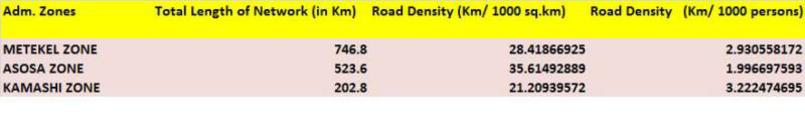
Benishangul Gumuz has an estimated area of 51,000 square kilometers and is located in the north-western part of Ethiopia. It shares common borders with the State of Amhara in the east, the Sudan in the north-east, and the State of Oromia in the south. It is divided into 3 administrative zones, 19 Weredas (two of them special Weredas), and 33 Kebeles (the smallest administrative units) [1]. Metekel is the largest zone with an area of 26,272 square kilometers followed by Assosa (14,166 sq. km), and Kamashi (8,850 sq. km) [2].
The state has diverse topography and climate. The later includes the familiar traditional zones - "kola", "dega", and "woyna dega". "About 75% of the State is classified as "kola" (law lands) which is below 1500 meters above sea level. The altitude ranges form 550 to 2,500 meters above sea level. The average annual temperature reaches from 20-250C. During the hottest months (January - May) it reaches a 28 - 340C. The annual minimum and maximum mean temperature registered at Asosa for the last 26 years is 12.40C and 27.80C respectively. The annual rainfall amount ranges from 500-1800mm. ..... The rainy season spreads through May to October." [1]. Altitudinally, the region ranges from 600 mete in areas bordering the Sudan to over 2500 meters. The state also has two major river basins, Abay and Akobo with smaller basins such as Dabus, Yabus, Dura, Julia, and Beles with significant potential for irrigation agriculture and hydro electric power generation. Its natural resources include precious minerals such as gold and copper.
Population Distribution
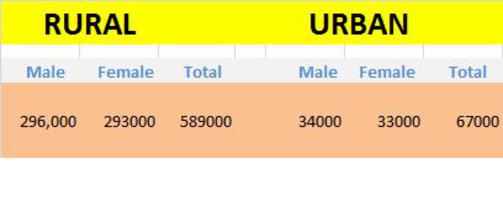
The mid-2008 CSA estimate puts the population size for Benishangul-Gumuz at 656,000, ninety percent of whom live in rural areas, indicating the very low level of urbanization. The percentage of urban population in the three Weredas - Metekel. Asosa, and Kamashi - is eleven, nine and zero percent. respectively. The regional state has a slightly masculine population (sex ratio 101.2). The urban-rural breakdown is as follows:
Source: [2]
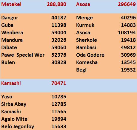
The table below shows the July 2008 population of Benishangul-Gumuz by Wereda. Asosa is the only Wereda with a population of over a 100,000. Three weredas, Wenbera, Dibate, and Pawe have populations between 50,000 and 60,000. Yaso is the least populated with just over 10,000 people, and has the lowest density..
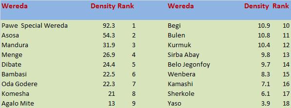
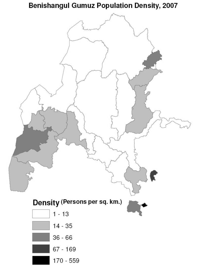
Most of Benishangul Gumuz is sparsely populated. The table below ranks Weredas in Benishangul-Gumuz by their density in mid-2008 (population per square kilometer). Pawi Special Wereda tops the list with 92.3 persons per square kilometers. Six Weredas have single-digit densities with another three in the 10 - 20 persons/sq. km. category.
Urban Population Distribution
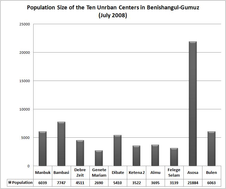
Benishangul-Gumuz has 10 urban centers with a population of 2000 or more, the largest being the State capital - Asosa. Four towns have a population ranging from 5,000 to 10,000.
Socioeconomic Characteristics
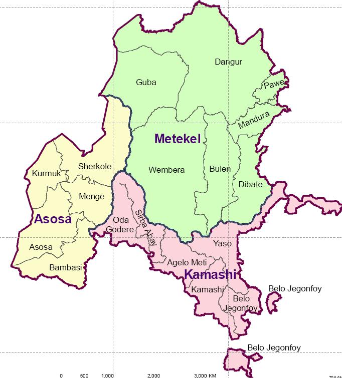
Agriculture is the mainstay of this regional State. A wereda level online report [3] states that in Menge Wereda, "...96% of the population are dependent on agriculture, and traditional gold mining is also an important activity". The report adds that in this Wereda and many others the population faces enormous challenges in accessing necessary social services including education and health care: "2006 figures show that Menge had 17 schools, including just one secondary school, and only eight health service institutions (one health centre, one clinic and six health posts). 50% of the urban population has access to potable water supplies, but the figure is only 38% in rural areas where the great majority of the population live." The report also covered Kurmuk Wereda (see map below) which is ".... situated in the far western side of the region. The Centre of the woreda at Kutaworke/Horazab is 89 km from Assosa. Like Menge the woreda is mainly lowland, and it covers a similar area of just over 1400km2, divided into 16 kebeles. However its population is less than half that of Menge, at around 21,000 people (2006 estimate), of which most are Berta. Kurmuk is linked with Assosa by a main road. This road is an important route between Ethiopia and Sudan, and there are plans to surface it with asphalt. As in Menge, agriculture is the major economic activity followed by traditional gold mining."
Source : [4]
The main annual crops grown in Benishangul-Gumuz include ".... maize, sorghum, haricot bean, sesame, noug (niger seed), millet and peanut". Meher growing season (April to September/October) accounts for 100% of the region’s annual crop production. Other sources of income in the region include "... small-scale gold mining (limited to some weredas), wild foods collection (threatened by heavy deforestation largely by wild fires and settlement activities) and wage labour." [5].
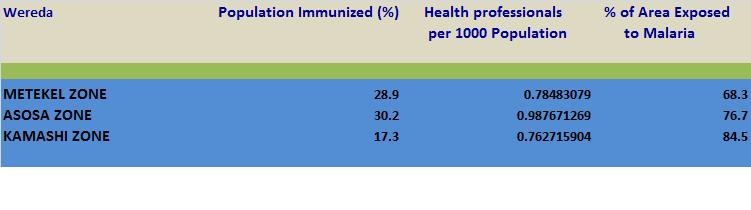
A 2004 World bank report placed this region in what it called "Ethiopia Three" in its classification of relatively uniform regions with socioeconomic risks/potential. "Ethiopia Three" includes the three zones in Benishangul-Gumuz, and many more in Amhara, Oromiya and SNNPR. [6]. The risks included malaria with 77% of Asosa and 85% of Kamashi affected. All areas in both Weredas (100%) also face trypanosomiasis (sleeping sickness) risks due to Tsetse Fly infestation. The regions potentials include irrigation agriculture - 14,142 ha. in Asosa, 26,595 ha. in Kamashi and 345,143 ha. in Metekel - none of which has been irrigated so far. The World Bank assessment also reveals that nine percent of the inhabitants of Asosa and Metekel have access to electricity; and no one in Kamashi does. [6]
Accessibility indicators (2004)
Health indicators (2004)
Education indicators (2004)
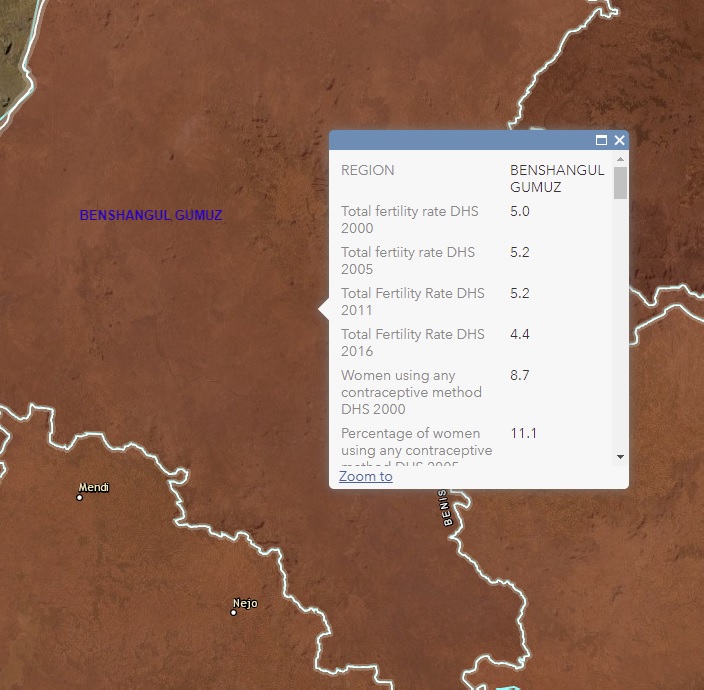
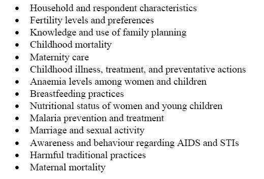
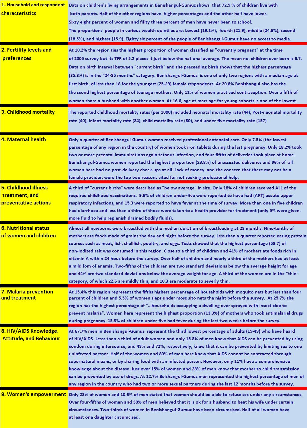
The following paragraphs and data are based on the 2005 Ethiopian Demographic and Health Survey (EDHS) [7]. As was discussed in the introductory section (main page of the web site) the 2005 survey focused on the following 14 variables:
The findings for Benishangul-Gumuz are as follows:
References:
1. http://www.ethiopar.net/
2.http://www.csa.gov.et/text_files/national%20statistics%202007/Population.pdf
3.http://www.rippleethiopia.org/page/bsg
4.http://www.ocha-eth.org/Maps/downloadables/BENESHANGUL.pdf
5.http://www.telecom.net.et/~undp-eue/reports/assosa0902.pdf
6.World Bank. Ethiopia Country Memorandum. Four Ethiopias: A Regional Characterization. May 2004.
7.Ethiopia Demographic and Health Survey 2005 Central Statistical Agency, Addis Ababa, Ethiopia , RC Macro,
Calverton, Maryland, USA, September 2006
Ethiopian Demography and Health
BENISHANGUL-GUMUZ
Source: [6]
Source: [6]
Source: [6]
If you would like to help update this page, please send comments and/or data (as an e-mail attachment) to the author:
Dr. Aynalem Adugna
at aynalemadugna@aol.com. Don't forget to indicate sources.